At a glance
Start: Ramthangkha road head, 2,250 m
Monastery: 3,120 m, about 870 m above the start
Distance: roughly 10 km there and back
On foot: 2–3 hours up, 1.5–2 down, about 5 hours with the visit
Halfway: the cafeteria, with tea and a toilet
At the door: phones, cameras and bags stay in a locker
Dress: shoulders and knees covered
Start by: 7am
Built: 1692–1694, at the cave of Guru Rinpoche; rebuilt after the 1998 fire
Walking figures are our own, the same as on the journey pages. Published figures for the road head vary between about 2,100 and 2,600 m; ours is where our vehicles stop.
Above the Paro valley, a monastery holds on to a cliff some 900 metres high. Its white walls and golden roofs sit at 3,120 metres, so close to the rock that in places the cliff is one of the walls.
This is Taktsang, the Tiger's Nest. Most people who come to Bhutan have seen its photograph long before they arrive, and what they want to know is whether they can reach it on foot. For most reasonably fit walkers, the answer is yes.
But the walk makes more sense once you know why anyone built here at all.
The tiger and the cave
Custom holds that in the 8th century Guru Rinpoche, the teacher who carried Buddhism into the Himalayas, came to this cliff on the back of a flying tigress. He came in a wrathful form, Dorje Drolö, to subdue the spirits that troubled the valley. In the account kept in Paro, the tigress was Tashi Kheudron of Mon, who transformed herself to carry him; other traditions name his consort, Yeshe Tsogyal.
He meditated in a cave in the rock face, and the cave became sacred.
Over the centuries, others followed him up the cliff to do the same. The poet-saint Milarepa is said to have meditated here for three years. Phajo Drugom Zhigpo, who brought the Drukpa teachings to Bhutan, came in 1219 and stayed for six.
For a long time there was little more than the cave, and the people willing to sit in it.
Building on a cliff
In the 1640s, the Zhabdrung Ngawang Namgyal, the lama who unified Bhutan, resolved to build a temple at the cave. He never did. The task passed to his spiritual heir, Gyalsey Tenzin Rabgye, and in 1692 the work began.
The story told in Paro is that the founding stones kept slipping from the ledge, because the cliff was too steep to hold them. Tenzin Rabgye cut hair from his own head and mixed it into the mud mortar. After that, the work went smoothly.
The temple was finished in 1694, and it stood above the valley for three centuries. Then, in April 1998, fire tore through the main building, taking paintings, statues and much of what had gathered there over that time. It was rebuilt, and restored by 2005.
What you walk to today is both very old and quite new. The cave is the old part.
The walk up
Pilgrims still make the climb, and the path has not changed its mind about how hard it is.
The vehicles stop at Ramthangkha, where the horses wait. The trail climbs straight away, switching back and forth through blue pine on a wide, dusty path. This first hour is the steepest of the day, and it helps to know that before you start rather than halfway up it.
After forty-five minutes or so the trees thin and the monastery appears across the gorge, further off and higher up than seems fair at that point. Keep going. The gradient eases from here, and the trail contours round the hillside to the cafeteria, a proper building with tea and a toilet, where most people stop for twenty minutes.
Above the cafeteria is the best stretch of walking: forest hung with prayer flags, climbing to the trail's high point, which sits slightly above the monastery. A small chorten marks the spot, with Taktsang straight across the gorge, close enough now to make out the carved woodwork.
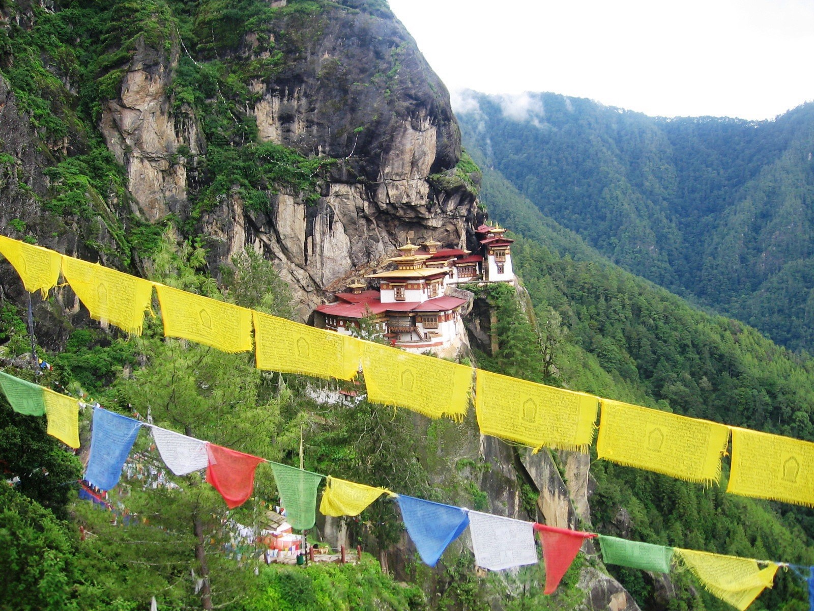
The viewpoint above the gorge: the trail's high point, and the last of the walking before the stairs.
Then the path drops. Around 700 steps lead down into the gorge, past a waterfall, and about as many climb back up to the monastery entrance. Nothing about them is exposed or dangerous. There are just a great many of them, and you take them twice more on the way back.
The climb tests your lungs; the stairs test your knees.
If your knees give you trouble, think about the descent before you think about the ascent, and bring poles.
Inside Taktsang
Everything is left at the entrance: phones, cameras, bags, all into a supervised locker. This is an active monastery, and the shrine rooms are for practice, not display.
It is smaller inside than the cliff face suggests. Shrine rooms and meditation caves are strung together by narrow wooden stairs, built into the rock rather than onto it. There are butter lamps, cold stone and the smell of juniper smoke, and usually far less noise than the queue outside would suggest. Most visits take thirty to forty minutes.
Cover your shoulders and knees, take off your hat, and walk clockwise. Your guide will show you where photography stops, which is at the door.
Why we start at seven
We aim to have people on the trail by 7am, and it changes the day more than anything else you can control.
The monastery faces roughly east-north-east, so the morning sun reaches it. By mid-afternoon it sits in its own shadow. The first hour has little shade, and it is a different climb at seven than at eleven. Most groups set off between half past eight and half past nine, so an early start gives you a quiet trail up and puts the crowd on the stairs as you come down.
What an early start won't give you is the monastery to yourself. Taktsang is the most visited place in Bhutan, and it is busy in every season. There is no quiet hour and no special access, whatever anyone tells you, and the place deserves better than being judged against a promise it can't keep.
Knowing where to stop
Trainers with a good grip are enough in dry weather. After rain the path turns to slick clay, and a boot with an edge earns its keep. Either way, wear something you have already walked in. You will be warm fifteen minutes after setting off and cold at the top once you stop, so carry a shell and a mid-layer. Take two litres of water: there is tea at the cafeteria and nothing above it.
The finish is above 3,000 metres. That is not dangerous for most people, but flying in and walking up on the same day is a poor idea.
Horses can take you from the road head to the cafeteria, uphill only. They don't go further, don't do the stairs and don't come down, so a horse saves you the steepest hour and leaves everything else as it was.
Before anyone starts, we tell them that the cafeteria and the viewpoint above it are both good places to finish. Walkers who know there is an honourable place to stop pace themselves better than those who think it is the monastery or nothing.
Nobody has regretted the viewpoint. A few have regretted pushing on past it on a bad day.
Where it fits in a week
Not on the first day and not on the last, though both are common. On the first day you have probably just come off a long flight and slept at 2,250 metres for the first time. On the last, one wet morning takes the centrepiece of the trip with nowhere to move it.
On the Sacred Valleys it is day five of six. By then you have spent several days between 2,300 and 3,100 metres and crossed Dochula, so your body has adjusted without your noticing, and there is still a spare day if the weather turns.
There is another way in. On the Bumdra Sky Camp you sleep on the ridge behind the monastery at about 3,800 metres and walk down to it the next morning, arriving from above and ahead of the crowd coming up, the way pilgrims did.
Most people come for the photograph, and from the viewpoint across the gorge it is exactly the picture they have seen before.
What has changed is everything around it. A cave a teacher once reached on a tigress. Stones that would not stay on the ledge until a man gave his own hair to the mortar. A fire, and a rebuilding. And now an hour of your own breath, and seven hundred steps.
The monastery was always going to be there. The walk is how you arrive at it the way it was meant to be reached: slowly, and on foot.
Sources
Paro Dzongkhag Administration: the tigress, the founding stones and the dates of building. John Ardussi, Taktsang Monastery (Project Himalayan Art, Rubin Museum), and his "Gyalse Tenzin Rabgye and the Founding of Taktsang Lhakhang" (Journal of Bhutan Studies, 1999). Neri itinerary data: elevations, distance and walking times, matching the journey pages. Bhutan Tourism FAQs: a licensed guide is required here, as at every monument. Our own guiding: timings, crowds, the horses and where to turn back.